


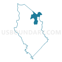
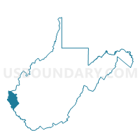
Voting District 52, Wayne County, West Virginia
About
Outline

Summary
| Unique Area Identifier | 691974 |
| Name | Voting District 52 |
| County | Wayne County |
| State | West Virginia |
| Area (square miles) | 30.40 |
| Land Area (square miles) | 29.30 |
| Water Area (square miles) | 1.10 |
| % of Land Area | 96.37 |
| % of Water Area | 3.63 |
| Latitude of the Internal Point | 38.27827030 |
| Longtitude of the Internal Point | -82.36004990 |
Maps

Graphs
Select a template below for downloading or customizing gragh for Voting District 52, Wayne County, West Virginia


Neighbors
Neighoring Voting District (by Name) Neighboring Voting District on the Map
- Voting District 36, Cabell County, WV
- Voting District 41, Wayne County, WV
- Voting District 42, Wayne County, WV
- Voting District 45, Wayne County, WV
- Voting District 48, Wayne County, WV
- Voting District 49, Wayne County, WV
- Voting District 49, Cabell County, WV
- Voting District 50, Cabell County, WV
- Voting District 50, Wayne County, WV
- Voting District 53, Wayne County, WV
Top 10 Neighboring County Subdivision (by Population) Neighboring County Subdivision on the Map
- District 4, Cabell County, WV (23,334)
- District 1, Cabell County, WV (17,746)
- Union district, Wayne County, WV (8,813)
- Stonewall district, Wayne County, WV (8,100)
Top 10 Neighboring Unified School District (by Population) Neighboring Unified School District on the Map
Top 10 Neighboring State Legislative District Lower Chamber (by Population) Neighboring State Legislative District Lower Chamber on the Map
Top 10 Neighboring State Legislative District Upper Chamber (by Population) Neighboring State Legislative District Upper Chamber on the Map
Top 10 Neighboring 111th Congressional District (by Population) Neighboring 111th Congressional District on the Map
Top 10 Neighboring Census Tract (by Population) Neighboring Census Tract on the Map
- Census Tract 101.02, Cabell County, WV (6,054)
- Census Tract 105, Cabell County, WV (5,837)
- Census Tract 205, Wayne County, WV (5,069)
Top 10 Neighboring 5-Digit ZIP Code Tabulation Area (by Population) Neighboring 5-Digit ZIP Code Tabulation Area on the Map
- 25701, WV (23,284)
- 25504, WV (12,661)
- 25570, WV (6,640)
- 25506, WV (5,037)
- 25535, WV (2,783)
- 25559, WV (2,152)
- 25512, WV (1,237)